Frosty Moss Relay Course Overview
Everything you could want to know is in this Frosty Moss Team Guide (PDF)
Paved legs follow the Olympic Discovery Trail, a multiuse path for runners, cyclists, walkers, and horseback riders. Relatively flat and fast, though you will encounter some rolling hills. Most of the ODT is separate from traffic, but it does share the shoulder with traffic in a few places. We’ve noted traffic situations in the descriptions below.
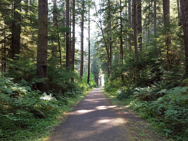
Unpaved legs follow the ODT-Adventure Route, which is flowy dirt singletrack. Not super technical, but definitely hilly. The Adventure Route’s long ups and downs will be a fun change of pace for your trail-happy teammates. NOTE: Mini Moss does not run on the Adventure Route. That course is all pavement.
How hard is this thing? We’ve omitted difficulty ratings because (a) what’s easy for you might be agony for your teammate, and (b) the Frosty Moss Relay course is pretty darn runner-friendly. Challenges arise with the leg distances, hilly trail legs, and the potential for all sorts of weather in the many microclimates along the way. (Also your stinky friends in your team van.)
Our advice: Check out the course guide and assign legs accordingly. (And bring big Ziplocs for your stinky running gear.)
Waves will be assigned based on your estimated average team pace as indicated on your registration. Please be as accurate as possible on your pace estimates. Do NOT pad your time because you are worried about making the cutoffs. If you run faster than your average pace and beat the exchange zone volunteers, your team will be held and made to wait. You do not have anything to gain by padding your average pace! Don’t worry! We will be sure to assign you a start time that will allow you to make the check points based on your ACTUAL average pace. In making your estimation, please plan for an additional 1 minute/mile for the Adventure Trail legs (legs 4-6). We will assign wave start times in early January for your planning purposes, but in general the waves will be structured as follows:
Frosty Moss Relay Start Times:
Wave 1 (11 – 12 minute mile pace): 6:00 a.m. start. Check-in starts at 5:15 a.m.
Wave 2 (10 – 11 minute mile pace): 7:00 a.m. start. Check in starts at 6:15 a.m.
Wave 3 (9 -10 minute mile pace): 8:00 a.m. start. Check in starts at 7:15 a.m.
Wave 4 (7 – 8.5 minute mile pace): 9:00 a.m. start. Check in starts at 8:15 a.m
DAWDLERS BEWARE! Teams must average a 12 minute pace or faster, including time spent at exchanges. Please take note of the cut off times.
ROADS ARE OPEN: Traffic rules apply. Runners and team vans must use caution at all crossings, along shared roadways, and exchange points.
Bookmark the Frosty Moss Relay routes on MapMyRun.
Distances are rounded to the nearest tenth or quarter mile. Click images and maps to enlarge.
START LOCATION:
The race starts at the Camp Creek Trailhead
Directions from Port Angeles: Hwy 101 west, past Lake Crescent, to approx MP212. Turn left at Cooper Ranch Road (Klahowya Campground is on your right). Volunteers will direct you to park along the road. Do not block the road. Drive time: Approximately 60 minutes.
Google map link: bit.ly/frostystart
Google Maps pin drop for Start Line – Camp Creek Trailhead
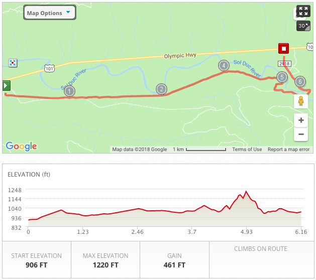
Leg 1: Start Line! ODT-Camp Creek Trailhead
Distance: 6.2 miles
Elevation Gain: 461 feet
Surface: Paved ODT and 1 mile of shared Forest Service road.
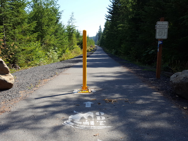
Highlights: Flat and fast. Sol Duc River views. Very, very green. The start line is the very western end of the completed Olympic Discovery Trail.
Traffic Alert: Last mile is on shared road. Logging trucks have the right of way.
View Leg 1 at MapMyRun
Google Maps Driving Directions to next exchange
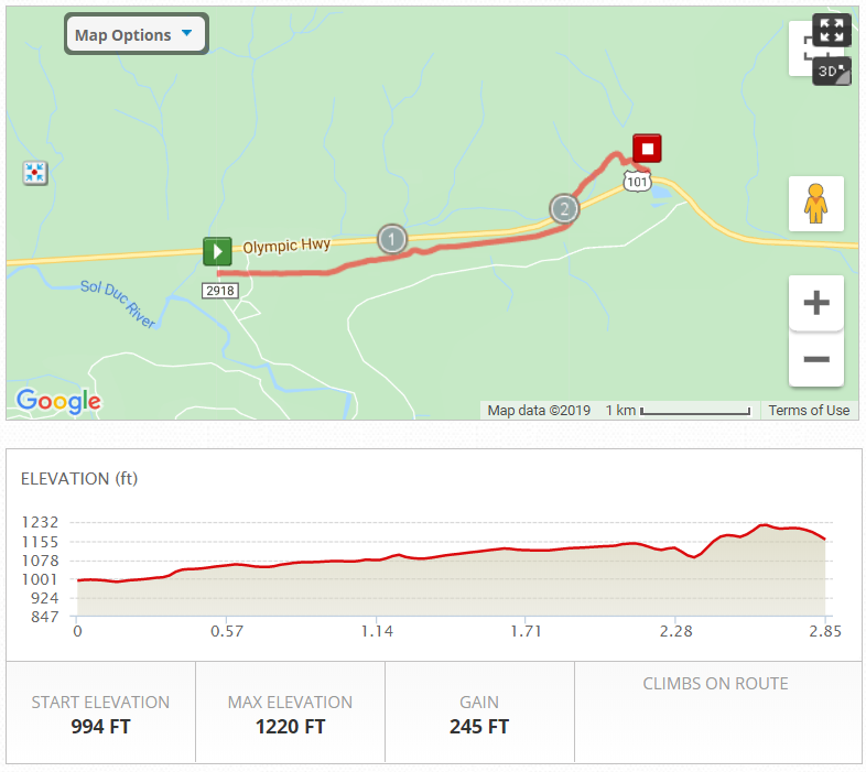
Leg 2: FS2918 to exchange
Distance: 2.85 miles
Elevation Gain: 245 feet
Surface: Paved ODT.
Highlights: Flat and fast. Buttery paved surface amid tall trees.
Traffic Alert: This leg crosses HWY 101. Cars have the right of way. Pay attention and take care of yourself.
View Leg 2 at MapMyRun
Google Maps Driving Directions to next exchange

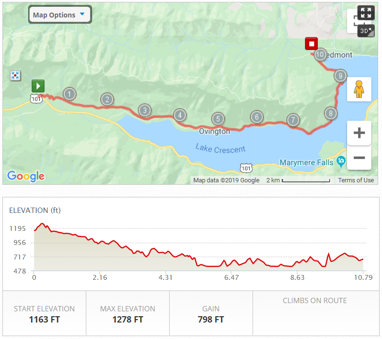
Leg 3: Spruce Railroad Trail, Lake Crescent, Olympic National Park
Distance: 10.8 miles
Elevation Gain: 100 feet
Surface: Mix of paved path, wide gravel regrade, and dirt trail.
Highlights: The entire length of the ODT-Spruce Railroad Trail. Run alongside Lake Crescent and through a restored railroad tunnel. Official route is through the tunnel, but you can take a short detour to the bridge over Devil’s Punchbowl on a trail to the right just before the tunnel (and if you keep going you come out on the far side of the bridge.
View Leg 3 at MapMyRun
Google Maps Driving Directions to next exchange

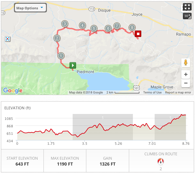
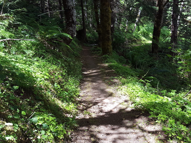
Leg 4: Adventure Route #1 (TRAIL)
Distance: 8.75 miles
Elevation Gain: 1,326 feet
Surface: About 3 miles of gravel road, then singletrack trail.
Highlights: East Beach to Joyce Access Rd. First leg of trail running. Lots of uphill on this one.
Traffic Alert: Traffic Alert: First 3 miles of gravel road is open to traffic. Cross Joyce-Piedmont Rd near MP5 – traffic does not stop.
View Leg 4 at MapMyRun
Google Maps Driving Directions to next exchange
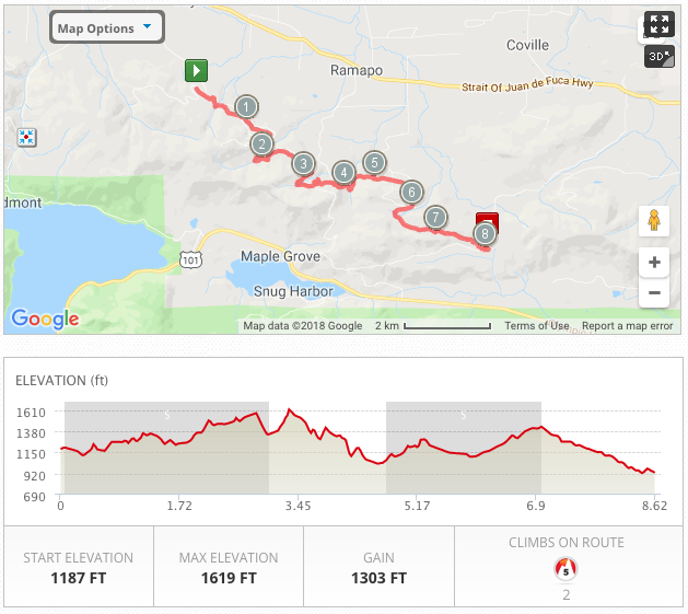
Leg 5: Adventure Route #2 (TRAIL)
Distance: 8.6 miles
Elevation Gain: 1,303 feet
Surface: Singletrack trail
Highlights: Joyce Access to Eden Valley Rd. Dense, moody forest with occasional views to Vancouver Island. Fun-to-run switchbacks and lots of hills.
View Leg 5 at MapMyRun
Google Maps Driving Directions to next exchange
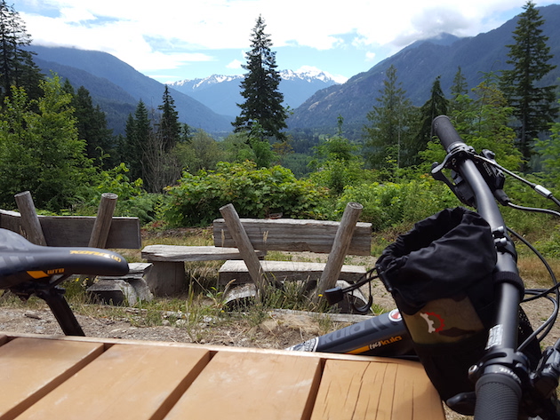
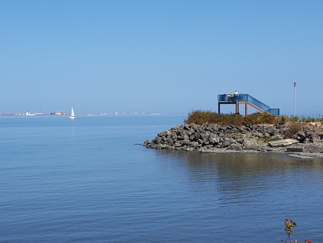
Leg 6: Adventure Route #3 (TRAIL)
Distance: 6.8 miles
Elevation Gain: 578 feet
Surface: Singletrack trail
Highlights: Eden Valley to the Dan Kelly Lot, another local favorite. Starts with a lovely long downhill before climbing to the Living Room (see photo, giant benches with views of the Bailey Range) and ends with a fun downhill to the exchange. PS: Sorry about that last hill.
View Leg 6 at MapMyRun
Google Maps Driving Directions to next exchange
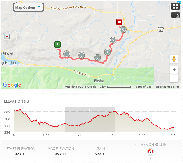

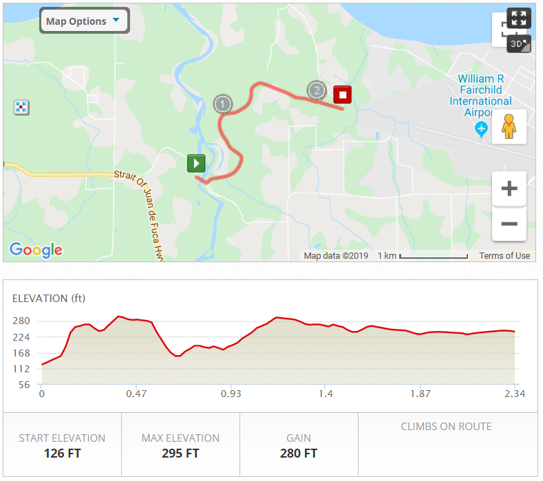
Leg 7: Elwha River Crossing 4:00pm CUTOFF
Distance: 2.3 miles
Elevation Gain: 280 feet
Surface: Paved ODT (no traffic) at Elwha River.
Highlights: After leaving the Adventure Trail, the team will drive their next runner to the start of Leg 7. This is a drop off point only, so have your runner ready to hop out of the car. The runner will be immediately treated to the view from the bridge over the newly wild and free Elwha River. Get ready for Leg 7 with a viewing party of Return of the River.
Cutoff Alert: Teams finishing this leg after 4:00pm must skip a leg and continue on (but will receive a DNF, no finish time)
View Leg 7 at MapMyRun
Google Maps Driving Directions to next exchange:
Step 1
Step 2
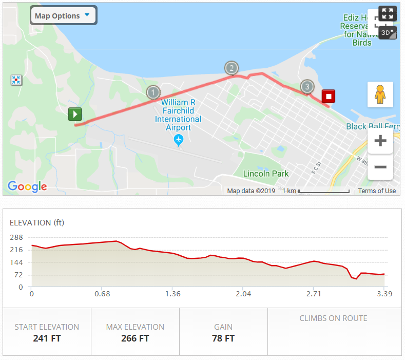
Leg 8: West Port Angeles
Distance: 3.4 miles
Elevation Gain: 78 feet
Surface: Paved ODT, neighborhood streets, sidewalk.
Highlights: Get into a speedy groove with a subtle downhill grade before the big downhill to the waterfront exchange at Port Angeles Yacht Club.
Traffic Alert: After mile 1 you will be on a combination of roadway and sidewalk. There will be traffic on the roads – BE ALERT!! Watch for course markings and watch for cars.
View Leg 8 at MapMyRun
Google Maps Driving Directions to next exchange
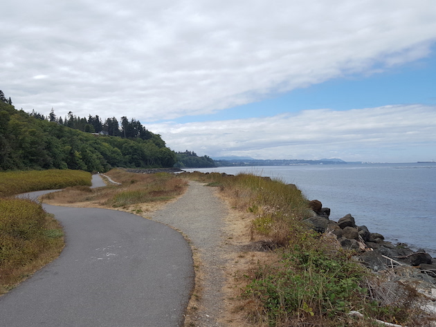
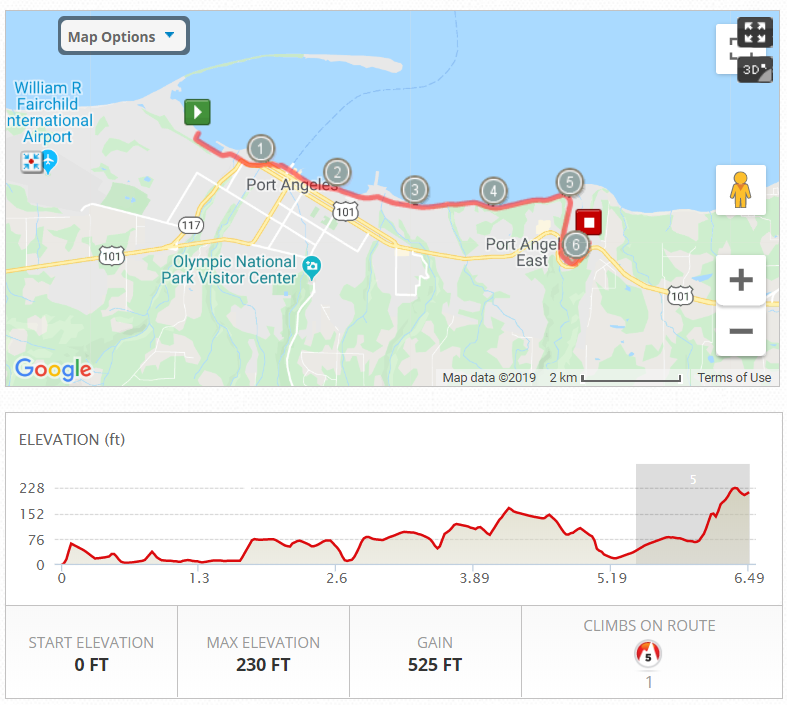
Leg 9: Port Angeles Waterfront
Distance: 6.5 miles
Elevation Gain: 525 feet
Surface: Paved ODT.
Highlights: Pure Strait of Juan de Fuca goodness. Watch for river otters! Save some energy for the climb at the end!
Traffic Alert: Watch for traffic at the street crossing after the Morse Creek trestle.
View Leg 9 at MapMyRun
Google Maps Driving Directions to next exchange
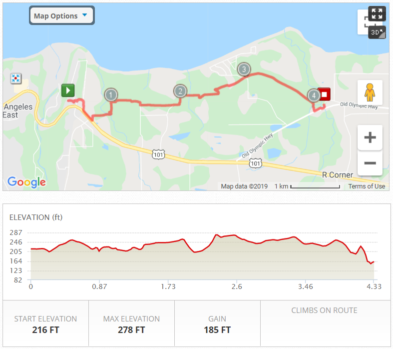
Leg 10: Deer Park to Old Olympic
Distance: 4.3 miles
Elevation Gain: 185 feet
Surface: Paved ODT.
Highlights: In a little bit you will get back away from the highway, and you do so via a big down and up at a covered bridge over Bagley Creek. But after that it’s lovely rolling hills through the trees all the way to Old Olympic Hwy at Siebert Creek.
View Leg 10 at MapMyRun
Google Maps Driving Directions to next exchange
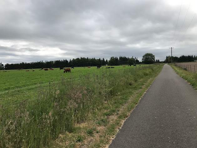
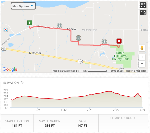
Leg 11: Robin Hill Country Park
Distance: 3.7 miles
Elevation Gain: 147 feet
Surface: Paved ODT.
Highlights: Make up for lost time entering the flatlands of Sequim. Forest gives way to working farmland. Say hello to the cows. It’s usually warmer and drier out this way, too. Welcome to the rainshadow.
View Leg 11 at MapMyRun
Google Maps Driving Directions to next exchange
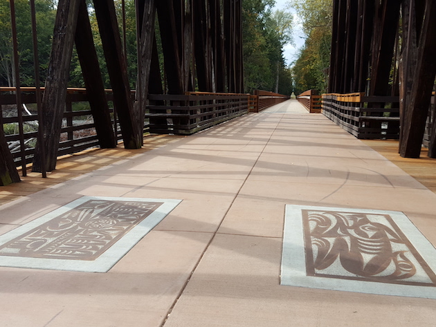
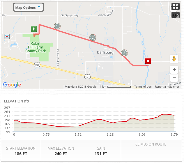
Leg 12: Dungeness River Railroad Bridge 8:00pm CUTOFF
Distance: 3.8 miles
Elevation Gain: 131 feet
Surface: Paved ODT.
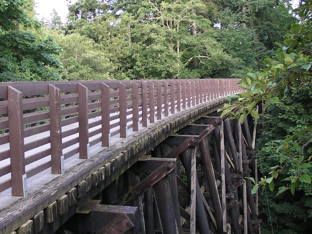
Highlights: In February 2015, a high-water event washed away the Dungeness River trestle. Thanks to the Jamestown S’Klallam Tribe, volunteers with the Peninsula Trails Coalition, and many others, the rebuilt trestle at the end of Leg 12 was ready for action just a year later. Check out the beautiful S’Klallam artwork embedded on the walkway.
Cutoff Alert: Teams finishing this leg after 8:00pm will be sent directly to the finish line party.
View Leg 12 at MapMyRun
Google Maps Driving Directions to next exchange

Leg 13: City of Sequim
Distance: 4.25 miles
Elevation Gain: 50 feet
Surface: Paved ODT, city sidewalks.
Highlights: A quick jaunt through Sequim (pronounced “Squim”), home to the annual Lavender Festival, Olympic Birdfest, and a retiree mecca, thanks to its location in the rainshadow and its walk/bike-friendly streets.
Traffic Alert: Lots of street crossings. Watch for course markings.
View Leg 13 at MapMyRun
Google Maps Driving Directions to next exchange

Leg 14: Sequim East. Almost There!
Distance: 2.91 miles
Elevation Gain: 125 feet
Surface: Paved ODT, city sidewalks.
Highlights: Begin at Sequim Chamber of Commerce. If you’re lucky (and if it’s still light out), the local elk herd will make an appearance along this stretch. Terrain gets a little rolly and the tall trees reappear as you head toward Blyn.
Traffic Alert: End of this leg/beginning of next is at a road crossing.
View Leg 14 at MapMyRun
Google Maps Driving Directions to next exchange


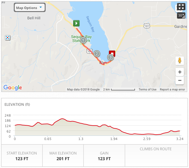
Leg 15: Finish Line in Blyn!
Distance: 3.25 miles
Elevation Gain: 123 feet
Surface: Paved ODT.
Highlights: Last leg! Recap the day with tall evergreens, another restored railroad trestle, a dash through Sequim Bay State Park, open prairie, a lovely net downhill grade, and the finish line after-party in Blyn at the Jamestown S’Klallam Tribe facilities! Way to go, Frosty Mossers! You did it!
View Leg 15 at MapMyRun
Google Maps Driving Directions to next exchange